With this Saturday's ride of the Coulee Challenge Permanent, I reached my 2012 goal of 6,000 RUSA kilometers. Any RUSA organized brevets or permanents count towards the annual total. I reached my total by riding a variety of brevets in Minnesota and Missouri plus the Shenandoah 1200 in the Mid-Atlantic region. I also rode permanents in Wisconsin and Connecticut.
Saturday's ride was a mixed bag. The Coulee Challenge is a beautiful ride. It was even more beautiful than normal this time as the faded colors and bright sunshine of late fall covered the hillsides. On the negative side, I had only ridden three times in the last month and my lack of conditioning was obvious as I struggled to climb A-Hole and Tamarack Hills. I actually rode fairly well for the first 80-ish miles, but then things got lots harder. I did manage to push through and ended up finishing the 125 miles in 8 hours and 56 minutes. Not the fastest time ever, but pretty decent overall.
The season isn't quite over yet. I hope to get in a few more rides and keep enjoying the fall for as long as the weather allows.
Monday, October 22, 2012
Wednesday, October 3, 2012


Thursday, September 20, 2012
Rando Road Trip
Last weekend, the Minnesota Randonneurs came to Black River Falls for back-to-back brevets. The idea was that randonneurs would have the chance to ride some new routes and we would all have the chance to get together over some beer and a meal to tell stories from the road. Overall, I had a great weekend and I'm pretty sure the other riders enjoyed their time in West Central Wisconsin.

On Saturday, we rode the Coulee Challenge route. The Coulee is a 200 kilometer course through the Coulee region south and west of Black River Falls. Nine riders showed up for the challenge. When we left at 8:00, the temperature was around 40 degrees, a sure sign that fall is on the way. The nine of us quickly broke into 3 groups. A lead group of 2 riders, my group of 5, and 2 others sweeping the course. I rode all day with Rob Welsh, Mark Olsen, Kelly Hines, and Glenn Seager. We finished the course in 8:34 minutes. This time was over 40 minutes faster than I have ever covered the Coulee route. Saturday evening everyone came to our house for chile, beer and tall tales.

Sunday morning came way too early. I was feeling less than perfect when I wheeled to the Holiday station for the start of the Dairyland Dandy, another 200km brevet. Seven riders showed up at the start to give it a shot. Without any real plan, we reached a consensus to ride audax style, basically riding together all day. My day was a little odd. Leaving the start area, I had lots of trouble clipping into my pedals. After 2 or 3 miles, I was finally able to clip in, but it would be an all day problem. All told, I rode over 60 miles with only foot clipped in. By the end of the day, we got into a pattern of prying my pedal open at the control, putting my shoe in, putting my foot in and then getting on the bike. Not exactly convenient but it was good enough to get me home. We finished the route in 9:40. Not exactly fast, but it was lots of fun riding with some fun people and sharing good conversation.


All in all, the BRF weekend was a success and plans are already in the works to get this on the Minnesota Randonneurs calendar for 2012.

On Saturday, we rode the Coulee Challenge route. The Coulee is a 200 kilometer course through the Coulee region south and west of Black River Falls. Nine riders showed up for the challenge. When we left at 8:00, the temperature was around 40 degrees, a sure sign that fall is on the way. The nine of us quickly broke into 3 groups. A lead group of 2 riders, my group of 5, and 2 others sweeping the course. I rode all day with Rob Welsh, Mark Olsen, Kelly Hines, and Glenn Seager. We finished the course in 8:34 minutes. This time was over 40 minutes faster than I have ever covered the Coulee route. Saturday evening everyone came to our house for chile, beer and tall tales.

Sunday morning came way too early. I was feeling less than perfect when I wheeled to the Holiday station for the start of the Dairyland Dandy, another 200km brevet. Seven riders showed up at the start to give it a shot. Without any real plan, we reached a consensus to ride audax style, basically riding together all day. My day was a little odd. Leaving the start area, I had lots of trouble clipping into my pedals. After 2 or 3 miles, I was finally able to clip in, but it would be an all day problem. All told, I rode over 60 miles with only foot clipped in. By the end of the day, we got into a pattern of prying my pedal open at the control, putting my shoe in, putting my foot in and then getting on the bike. Not exactly convenient but it was good enough to get me home. We finished the route in 9:40. Not exactly fast, but it was lots of fun riding with some fun people and sharing good conversation.
All in all, the BRF weekend was a success and plans are already in the works to get this on the Minnesota Randonneurs calendar for 2012.
Friday, July 27, 2012
Pedaling New England

I've spent this week hanging out in Stonington, Connecticut with my family. We've been to the beaches, toured some historic sights, visited the Acquarium, done some shopping and made numerous strolls through Stonington Borough. I've also had the chance to enjoy some great cycling along the shaded, winding roads of the area. On Sunday, I rode 40 miles on a route I found on Ridewithgps.com. The route wound through the quiet roads around Stonington and Mystic with a nice mix of forested lanes, river views and seascapes. On Tuesday, I rode the Connecticut Yankee 107 km permanent route owned by Jennifer Wise. Jennifer's route included more country lanes and lots of historical sites. I especially enjoyed riding sections of the Washington-Rochambau route, this was part of the route Washington's armies travelled during the revolutionary war. The area was also flush with homes dating to the 1750's and lots of really old cemetaries.
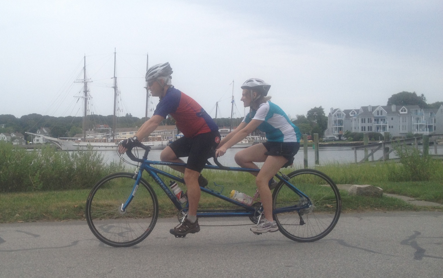
On Thursday morning, Heather and I realized a long time desire to try out a tandem. We rode 40-ish miles in total. That included a redo of Sunday's route plus a section with the girls and Grandpa Tom along scenic River Road outside of Mystic. The tandem ride was really a lot of fun and we only had a couple of awkward moments. No crashes, no blood, and no "team meetings".


This morning, I got up early and did another 25 miles. All in all, I got in about 180 miles this week on vacation. I wasn't really expecting to find a cycling paradise in Connecticut but I think I just might have.
Sunday, June 17, 2012
2012 Shenandoah 1200 km Ride Report: Blue Ridge Climbfest
I have to admit being a little intimidated as I straddled my
bike at the start of the 2012 Shenandoah 1200. Although I had finished three
prior 1200 kilometer events, Shenandoah boasts approximately 50,000 feet of climbing over 4 days.
Additionally, prior editions of the Shenandoah have been marked by extremely
high temperatures.
In almost every way, Shenandoah
is the opposite of PBP. For starters, only 13 riders were lined up to start the
event. In Paris, the start was punctuated by speeches from dignitaries,
cheering crowds and a strolling musical group. At Shenandoah, Matt Settle’s
start line speech consisted of “you’re all experienced randonneurs, you know
what to do. I guess you can go then.”

The group stayed together as we
left Leesburg, Virginia in the pre-dawn darkness. The ride started with miles
and miles of sharply undulating terrain through Virginia horse country. An
early highlight of the ride was crossing the Potomac River just as the first
light of dawn made it possible to see the surroundings. The early morning pace
was quick and we ended up arriving at the first control at the Gettysburg
Battlefield ahead of schedule. In fact, Matt Settle had not yet arrived to set
up the control. After a couple of minutes, we decided to have one of the other
riders, an RBA from Kentucky, sign the cards documenting our progress. As we were winding our way around and through
the Gettysburg Battlefield and its solemn monuments, Matt found us and offered water
and a selection of snacks. Throughout the morning I had been riding with Rob
Welsh. We now added Mark and Bill Olsen to our group. The four of us would
remain together for most of the rest of the day.
The section between the
Battlefield at Gettysburg and the Battlefield at Antietam included crossing a
covered bridge and several steep climbs. Overall, the route included more of
the sharply rolling terrain that would punctuate the entire route. We arrived
at the second control at the Battleview Market in Sharpsburg, Mayland in time
for well-earned lunch. We saw most of the other riders at the control, as the
group was still hanging pretty close together.
The early morning’s fast pace had allowed us to cover the first hundred
miles in around seven hours.

The next section included a brief foray into West
Virginia and more rolling terrain. Our group of myself, Rob and the Olsen
brothers stayed together and kept up a steady, fast pace. A favorite part of
the afternoon was riding on a road which ran along a high ridge with a valley
and mountain range on each side. We
arrived at the overnight control at the Crimson Inn in Bridgewater, Virginia
around 9:30 pm. Just in time for a lasagna supper and a few hours of sleep.
Over the course of day 1, we
covered 234.5 miles. According to Rob’s GPS, we gained 15,800 feet in
elevation.
Day 2 would be the hardest day of
Shenandoah for me. We left Bridgewater, Virginia before 5:00. Rob and I rode
out with Ian Shopland from the Seattle Randonneurs. The early morning darkness
was cool as we encountered rolling terrain leaving town. Eventually, we began a
long, gradual climb as dawn broke. During the long descent, it seemed like the
temperatures plummeted until finally dropping into the lower 40’s. Neither Rob nor
I had prepared for cold weather- Shenandoah is known for heat afterall. After
trying to tough it out for several miles, we finally pulled to the side of the road and put our hands under
our armpits to try to get some feeling back into our fingers. As the sun took effect, temperatures rose
enough to make for some beautiful miles highlighted by a section winding along
and above the Maury River.

Following up on a tip from
Ontario Randonneur David Thompson, we took advantage of the hospitality of the
Effinger Volunteer Fire Department neat Enfield for a bathroom and water
break. The break energized us for the
next segment including the Buffalo Road climb which was one of my favorite
climbs of the ride. The climb on Buffalo Road was a winding, gradual climb that
extended for nearly 10 miles. For parts of the climb, the road paralleled a
small stream. At other times the road passed open expanses where we had nice
views of distant mountains.

Although the climb was enjoyable, it was still
a climb and by the time we arrived in Buchanan around mid-day, I was tired and
hot. The control was a combination convenience store/Burger King. Even though
fautgue and the heat made it difficult, I ate as much as I could. The 15 mile section after Buchanan featured
terrain that was more moderate and lacking any serious climbs. That would
change, however, when we reached the outskirts of Roanoke. Leaving Highway 11,
we started a quick steep climb up aptly named Mt. Pass Road, before rolling
into Roanoke. The final leg into Roanoke included a stretch through heavy car
and truck traffic which appeared to be stuck in a perpetual traffic jam.
Because we had heard cautionary tales of the climb to the Blue Ridge Parkway,
we had decided to take a quick break in Roanoke to top off out water bottles
and have a snack. Shortly after the stop, we came to Ivy Street, which Mark
Olsen had been warning us about for several days. Mark was right. Ivy Street
started the climb to the Blue Ridge Parkway with a two block stretch that neared
20%. After turning from Ivy Street, the climb mellowed and the rest of the 3 or
4 miles was a steady doable climb up Mill Mountain. The left turn onto the
parkway came soon enough, but it wasn’t anywhere near the end of the climbing.
For the first several miles on the parkway, we would climb for half a mile or
so and then descend back to the starting elevation only to start another climb.
I thought this was a drag until I got into the remaining section of the
Parkway. The last 7 or 8 miles on the parkway were one long steady climb which
brought us to an elevation around 2800 feet, approximately 1700 feet above
Roanoke.
We finally left the quiet of the
Parkway, and joined the Floyd Highway. The Floyd Highway was a two lane road
that winds along the highlands with a fairly large amount of traffic.
Unfortunately, the road doesn’t have a shoulder for riding. Both Rob and I felt
uncomfortable about riding on this 20 mile stretch of highway because of the
near constant traffic and the need for cars to back up behind us waiting for a
chance to pass. Fortunately, nearly all of the drivers we encountered were
patient and we didn’t have any really close calls. The control at the Pine Tavern Lodge near
Floyd was a brief stop for snacks before we rolled into Floyd for a more
substantial dinner. By the time we got to the Subway, I was seriously tired and
overheated and unsure of what I could eat to get me through the evening hours.
I eventually chose a personal pizza and some chips. Eating when overtired and
overheated can often be a challenge, but I was able to get through most of my
supper. We left at 7:30pm ready to face the remaining 45 miles to the overnight
stop in Mt. Airy, North Carolina.
Within a couple of miles of
leaving the control, we got onto the small country roads which dominate this
section. It was also clear right away that we were not done climbing for the
day. In fact, the remaining miles of the day featured a constant barrage of
climbs and descents. No one climb was particularly memorable but they just kept
coming. The scenery was good and there was very little traffic. We finally
arrived at the summit of the descent into Mt. Airy and stopped to put on warm
clothes for the long drop into town. The first three miles of the descent were
a rush. We were flying along a smooth roads and really enjoying the swithbacks.
After the three miles, the road turned up again for a half mile climb. I
remember thinking that only in Shenandoah could you find a descent which
required climbing. The lower portion of the descent was at a more moderate
grade. The most noticeable feature were the large number of dogs which came out
to chase out as we crossed into North Carolina.
We eventually made it to Knights Inn Motel just before midnight. I
loaded up macaroni and cheese and elevated my legs befor going to bed. While I
was sitting with my legs up, I spent some time wondering how I was going to repeat
the last 45 miles first thing in the morning.
When we were getting on our bikes
to roll out around 5:00 am, the last rider on the road was just rolling into
the hotel. He had apparently had a very rough night in the mountains and was
hoping to get a couple hours of sleep before heading back out.
Our morning ride started with the
long climb up Willis Gap road that we had descended in the dark the previous
night. Fortunately, the first miles of the climb were relatively gradual and
passed without any problems. The famous dogs of the mountain did not make an
appearance. I suppose someday they will learn that its easier to catch cyclists
riding 8 mph than 30mph, but at least it wasn’t on my trip to Shanandoah. The upper stretch of Willis Gap road was a
beast of a climb. The road climbed at a steady grade of around 8% for three
miles. At this point of the ride my legs did not have much strength but I was
able to keep moving and eventually reached the top about 100 yards behind Rob.
The remaining miles to Floyd were
tough but manageable. The section, which had seemed nearly impossible in the
previous night’s darkness, was now doable, even though it was still tough
going. One spot in particular along
Gladesboro Road almost brought me to my knees. The road had one short
climb of about a quarter mile that was almost as steep as anything I have ever ridden. In fact, the guy working at the country store
down the road from there on the Danville
Pike said that his hot rod car bogs down on that climb. The country store was
notable for its huge collection of aluminum cake molds hanging all around the
walls and for its unusual snack food options.
We arrived back at the Floyd control around 11:30am. The 45 mile section
had taken us 4.5 hours each way.

At the Floyd control, Ruby made
Rob and I each a great ham and cheese sandwich to get us through the afternoon.
After leaving Floyd, we had to contend with 20 more miles of the Floyd Highway.
The traffic on this stretch didn’t seem as bad, either because it was lighter
on Saturday or because fatigue was causing us to tune it out. After passing the turnoff to the Blue Ridge
Parkway from the previous day, we came around a corner and saw the road drop
away into Roanoke. The unexpected long descent into Roanoke raised my sprits.
The three mile twisting descent into Roanoke was pure cycling bliss. The road
was winding enough that we could go as fast as cars so we were able to take up
the whole lane and just enjoy the ride. At the bottom, we pulled into a
Kroger’s grocery store to get out of the heat and look for a snack. We ended up
going into the Deli and coming out with a full chicken dinner, complete with
mashed potatoes and dinner rolls.

Again we had to wind through
Roanoke and back to Highway 11. The climb over the Mt. Pass Road seemed more
manageable in this direction and we were able to get back to Buchanan for
another Burger King break. Leaving Buchanan around supper time, we had around
70 more miles to ride for the day. The
way I was feeling, I thought I would be lucky to average 10 mph on this
section. Additionally, I had been worried
about traffic on the long stretch along Highway 11 that was to follow the
Buchanan control. In actuality, the road
was very rideable. Although the road was a two lane road without a good
shoulder, the traffic was not very heavy and the grades on this major highway
provided a lot of relief for tired legs.
Somewhere along this section we rolled through Lexington, Virginia. I
think Lexington was one of the most beautiful towns we saw on the entire route.
The town featured stately, historic homes a beautiful downtown, and the final
homes of Stonewall Jackson and Robert E. Lee. The evening did prove to be a
slow slog until about 35 miles out when Rob got a burst of motivation and was
able to get out pace revved up to around 20 mph for the last hour or so. I was surprised when climbing a steep hill in
Staunton to look over and see the Woodrow Wilson Presidential Library. A lit up
glass room contained his favorite car, a 1919 Pace Arrow limosine. We arrived back at the Crimson Inn in
Bridgewater around midnight, knowing that we only had 130 miles to go to the
finish.
We started the fourth day of
Shenandoah around 5:00am. The final day would prove to be relatively
uneventful. We rolled along at a nice conservative pace until stopping at a
church near Edinburg for a water and bathroom break. The climb up Edinburg Gap,
the final major climb of the ride, was a steady 3 or 4 mile climb over shady
roads. We stopped for another break in the small town of Fort Valley. A pop
machine provided drinks and a volunteer fire department provided the bathrooms.
We then rode a very scenic section of road though the George Washington
National Forest into the final control in Front Royal, Virginia.

The final segment of the ride was
a return to Leesburg through rolling horse country. This area featured huge country estates and
narrow winding roads. Unfortunately, these roads had fairly heavy traffic and
impatient drivers. Rob nearly got hit when a passing car tried to duck in
between Rob and I to avoid oncoming traffic and came within inches of hitting
Rob’s rear wheel. We arrived back in Leesburg at 4:54 pm. Our total time for
the Shenandoah 1200km was 84:54.

All in all, I had a great time at
Shenandoah. I enjoyed many miles of scenic roads through beautiful, rugged
country. I had lots of fun riding with
Rob and got through the ride without any serious problems. The ride is
definitely a low frills affair. Rob’s GPS recorded over 53,000 feet of
climbing. That worked out to around 15,000 for each of the first three days and
around 7,000 for the last day.
Sunday, June 10, 2012


Saturday, June 9, 2012
Day 3 recap
Today was another long day. We left Mt. Airy, North Carolina at 5:00 am. The day started with a steep 7 mile climb to the Blue Ridge Parkway followed by 30 miles of constant up and down. The descent into Roanoke was awesome. Several miles of banked hairpin corners on good pavement. Temps were in mid 90's which totally zapped us. The evening was a total slog until Rob provoked a second wind which got us to Bridgewater, Virginia at 11:55.
Tomorrow is about 130 miles. Supposed to be hot!
Sent from my iPhone
Tomorrow is about 130 miles. Supposed to be hot!
Sent from my iPhone
Descent into Roanake

Friday, June 8, 2012

Day 2
In Buchanan, Virginia. Done 97 hilly miles. Legs were dead most of the morning. Climbing up to the Blue Ridge Parkway next. 115 more miles today. Tomorrow is supposed to be a little easier.
Sent from my iPhone
Sent from my iPhone
Thursday, June 7, 2012

Day one recap
Great fast day. Very hard. 234 miles in just under 18 hours. Lots and lots of climbing. Hoping for good sleep and some recovery.
Sent from my iPhone
Sent from my iPhone

Wednesday, June 6, 2012

Shake Down Cruise
We arrived here in Leesburg, Virginia early Tuesday afternoon and have been slowly getting everything organized to start the ride on Thursday morning at 4 o'clock. As the ride gets closer and we spend more time looking at the ride details, things are coming into focus. According to the mapping that Rob has been doing, the 50,000 feet of climbing may be conservative. His GPS program is showing 17,000 feet for each of the first two days and a ride total of approximately 58,000 feet. Should be interesting.

This morning Mark, Rob, and I went for a 20 mile shake down cruise on the W & OD bicycle trail. The bikes all seemed to be in order. Now we are just spending a quiet afternoon waiting for bike inspection and check-in later this afternoon.
This morning Mark, Rob, and I went for a 20 mile shake down cruise on the W & OD bicycle trail. The bikes all seemed to be in order. Now we are just spending a quiet afternoon waiting for bike inspection and check-in later this afternoon.
Sunday, June 3, 2012
Shenandoah Preview
Tomorrow morning we are loading up the van and heading east towards Leesburg, Virginia. Myself, Mark Olsen, and Rob Welsh are slated to start the Shenandoah 1200 kilometer grand randonnee early Thursday morning (June 7th). The route distance is somewhere around 750 miles and riders have 90 hours to finish the course. The Shenandoah route is reputed to be extremely scenic and very hilly. The route starts in Leeburg, Virginia and passes through a couple of Civil War battlefields before entering the Shenandoah Valley and Blue Ridge Mountains. The ride is advertised as having around 50,000 feet of climbing.
The official ride website describes the route as follows:
The route begins heading north from Leesburg, VA to Gettysburg, PA with a climb over the Catoctin Mountains in Maryland. It then heads west, once again climbing over the mountain to the Antietam Battlefield. Once in the Shenandoah Valley the terrain moderates with views of the Blue Ridge and Allegany Mountains. As the route proceeds south skirting Winchester, VA, the terrain becomes continually rolling as Massanutten Mountain replaces the Blue Ridge on the east. As the route progresses up the valley the rollers increase and the valley narrows. Finally the route climbs up the Blue Ridge parkway and visits Floyd, Va and Mt Airy, NC (Mayberry) before turning around and heading north. After passing thru Roanoke, VA the route follows US 11 (the Mother Road of the Valley) to Harrisonburg, VA. A turn to the east gives riders a gentle route out of the valley over Edinburg Gap to the finish in Leesburg.
I also found a link to a map of the route. The map is a couple of years old so I would assume its not exactly accurate for this year's version, but it looks pretty close.
http://www.mapmyride.com/s/routes/view/road-cycling-map/pennsylvania/gettysburg/36483042
I think that I am in reasonably good shape for the ride. I didn't realize how tough it would be to get in shape for a 1200km ride by the first week of June. Fortunately, we had a good spring for riding. I have been able to get in about 2500 miles. Included in that total is a 400km ride, 3 300km rides and 6 200km rides. That is about as good of preparation as I could hope for to prepare for a ride this early in the season. We'll see what happens.
I hope to do some e-mail posting to this site from my iphone during the ride. We'll see how my energy levels hold up. I will also be using my Spot locator to post location updates. A link to the Spot map can be found on the upper left of the blog page.
Sunday, May 20, 2012

Sunday, April 29, 2012
Kansas City 400km
Most people think that riding a bike 250 miles in a day is crazy. Driving 8 hours to do so is even worse. However, I have signed up to ride the Shenandoah 1200 kilometer ride and need to ride a 250 ride before the end of May to qualify. Unfortunately, none of the clubs in the Upper Midwest offer a 250 mile ride in time to help me. So, Kansas City here I come.
On Saturday, I showed up in Liberty, Missouri to ride the 400 kilometer brevet with the Kansas City Ultracycling gang. At sign in, I immediately recognized three guys that I have ridden with before. I had ridden with Spencer Klaasen and Jack Romans at my first ever 600 kilometer brevet, which I did in 2008 in Lincoln, Nebraska. I also knew Dan Clinkenbeard whose crazy storytelling had kept our group in stitches during the last day of the Granite Anvil 1200 kilometer brevet in 2009. Dan is famous for never, ever moving to the front of the group to take his turn pulling riders to reduce air resistance.
We started the ride just before sunrise in the darkness of a strip mall parking lot. Kansas City's RBA, Bob Burns, started the pre-ride meeting with a new-to-me practice of having everyone introduce themselves to the group. In all, there were about 15 riders lined up. With a casual, "Well, I guess you can go", we were off into the morning.


Within a couple of miles, the field had broken into several small groups. I fell into a group with Spencer, Dan C., and Rod. Following the course proved to be about as easy as possible, we simply followed US Highway 69 from the outskits of Liberty, Missouri to Davis City, Iowa. Fortunately, Highway 69 parallels Intertate 35 so traffic was minimal for most of the route. Although we were heading into a steady 10 mph headwind over non-stop rolling hills, we maintained a nice pace for the 72 miles to the first control in Pattonsburg, Missouri. At Pattonsburg, we added two more riders to our group, Karen and Keith. This group of 6 would stay together for the rest of the ride. Because there were 2 Dans in the group, I was referred to as "Dan who pulls".

We averaged 14.2 miles per hour while riding and reached the turnaround at 3:35pm, a time of 9 hours and 35 minutes for first 200 kilometers. The turnaround was at a tiny post office in Davis City, Iowa. To prove that we had been there, each rider had to mail a postcard back to the ride director.

On the ride back to Liberty, the 10 mile per hour winds pushed us along nicely. The hard effort of the northbound leg was replaced by a more conversational, light-hearted spin. The only drama of the day occured when lightning started lighting up the sky as we approached Lawson, Missouri, about 20 miles from the finish. After a team meeting, and a flurry of smart phone weather research, we decided that the worst of the storms would miss us so we headed on towards Liberty. The skies opened up and we rode through steady rains for about 10 of the remaining 20 miles but we all arrived at the finish safe and sound, albeit wet.
I finished at 1:25am for a total time of 19 hours and 25 minutes.
Sunday, April 8, 2012
Heating Up...sort of
The strange spring weather in Wisconsin has allowed an early start to the 2012 cycling season. As of April 8th, I am already up to 880 miles for the season and have ridden two 75 mile rides, two 125 mile rides and one 180 mile ride. The 180 mile ride was Saturday's debut ride of a route I created called "Old Abe's Parade". The route is certified as a RUSA permanent which allows riders to gain RUSA credit towards various distance awards. The ride starts in BRF and travels to Pepin by way of Independence, Mondovi and Durand and returns through Alma, Arcadia and Ettrick.

I left at 6:00 am under clear skies and with a beautiful, setting full moon. The temperature at the start was 28 degrees. The ride to Durand was awesome across terrain that became increasingly hilly. The section between Durand and Pepin is one of my favorite roads to ride anywhere in the state. County Highway N travels parallels the Chippewa River and the Tiffany Bottoms Wilderness area. I saw multiple bald eagles and was lucky enough to watch one eagle scoop an unlucky fish out of the water as I rode past.
Just as I was leaving Pepin, the predicted 30 percent chance of rain turned into a steady drizzle that would last over the next 5 hours. I rode southeast along the Great River Road trying to enjoy the regular views of the Mississippi River and adjacent bluffs. The climb over the bluff out of Alma was a long, steep and soggy grind. By the time I got to Arcadia, I was soaked, freezing, and in full bonk mode. A meal and some hot chocolate gave me enough energy to limp over the two climbs which highlight the section to Ettrick. Things finally dried out shortly after leaving Ettrick and I was treated to glorious light as the sun set halfway between Ettrick and home.
I finished the 181 mile ride in 14 hours and 39 minutes. Not an elite time by any means but I was pretty satisfied with being able to complete a ride of that difficulty in bad conditions so early in the season.
Sunday, January 8, 2012
First Miles of 2012
Today I took advantage of the winter that isn't (at least so far) and rode 30.5 miles. Who would ever believe that we would have a 35 degree sunny day with no snow or ice on January 8th. At a dinner last week the girls told me that I should have a goal of riding 1,000 miles this year. ( I don't think they know how many miles I rode last year) It's never too early to start working towards a goal! Only 969.5 miles to go!
Subscribe to:
Comments (Atom)